
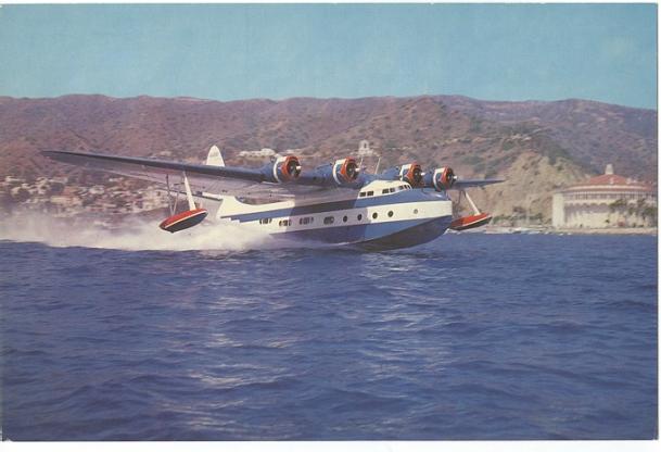
Pan American B-314 Clipper Flights
Thanks to Bjorn Larsson of www.timetableimages.com
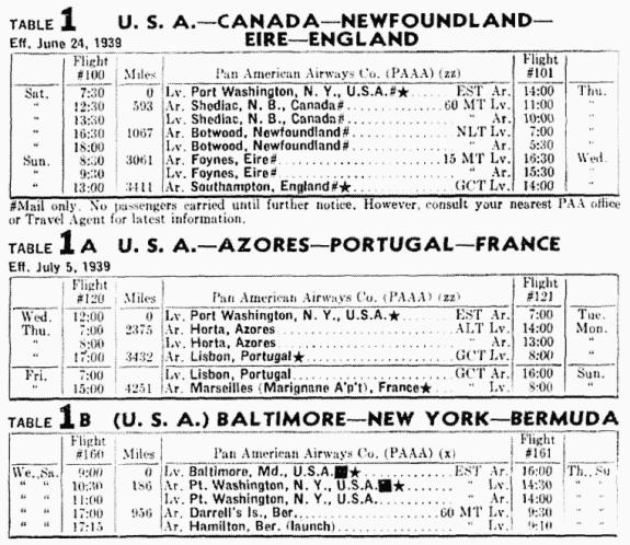
I have recently received copies of the 1939 Pan Am Clipper
timetables below. This new information
will prove some of my conjectures regarding operations to be incorrect.
|
Flight# |
From/To |
ICAO |
Est, Time |
Distance |
|
PA101 |
New York Shediak NB Botwood NF Foynes Ireland |
KLMT CYSK CYBW EIFN |
03:30 02:45 11:25 |
522nm 409nm 1733nm |
|
Flight# |
From/To |
ICAO |
Est, Time |
Distance |
|
PA102 |
Foynes Ireland Botwood NF Shediak NB New York |
EIFN CYBW CYSK KLMT |
11:25 02:45 03:30 |
1733nm 409nm 522nm |
Bluegrass Virtual Airline Pilots report these flights to the Northern Division Director
This flight is best flown in the long days of summer.
Here is how I flew it. Date was set to June 24th
|
LaGuardia Marine Air Terminal |
NDB 752.0 |
Lv 08:00 |
|
Shediak New Brunswick |
NDB 755.0 |
Ar12:30 3hrs 30min Lv 13:30 |
|
Botwood, Newfoundland |
NDB 756.0 |
Ar 16:15 2hrs 45min Lv 18:15 |
|
Foynes, Ireland |
NDB 757.0 |
Ar 09:40 11hrs 25min |
The Clipper taxis across the Shannon River to the Foynes Ireland dock.
|
Foynes, Ireland |
NDB 757.0 |
Lv 21:30 |
|
Botwood, Newfoundland |
NDB 756.0 |
Ar 05:10 11hrs 40 min Lv 07:10 |
|
Shediak, New Brunswick |
NDB 755.0 |
Ar 09:55 2hrs 45 min Lv 10:55 |
|
LaGuardia Marine Air Terminal |
NDB 752.0 |
Ar 13:25 3hrs 30min |
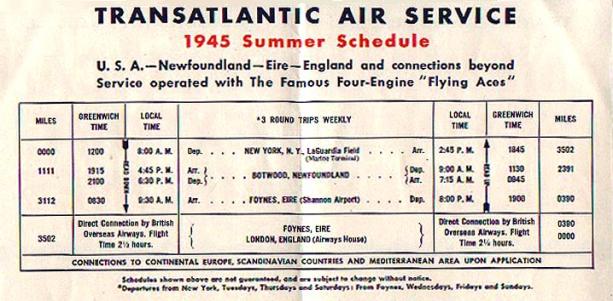
The following schedule and postcard images are from the collection of Craig Morris.
Check out some of the
airline collectibles he has for sale at: www.thepostcard.com/craig
When I saw
the schedule I asked him for information on the “Flying Ace”, which he supplied
along with images of the postcards below.
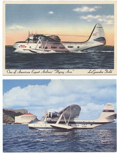
The Flying Ace was a Vought Sikorsky VS-44 flying boat used Exclusively by American Export line(initial operator), Antilles Air Boats line, Avalon Air Transport. Basically: crew of 9, 26/50 passengers, 80ft long,28ft high,124ft wing span, gross wt. 58,000lbs, 4 Pratt&Whitney Twin Wasp Radials, range 3600 miles, 19,000ft ceiling, cruise 160mph, test flight 8/13/37, Initial operator/service 6/22/42 by AEA. They used PBYs in late 30's for survey flights to which I have 2 Real photo postcards--and 1 autographed by the entire crew. Really started contract govt. services 1/12/42, Govt. terminated services Jan 1945--they worked for ATC for a short time.
To take off empty the auxillary tanks (otherwise the B-314 won’t budge) When you get it moving you can fill the auxillary tanks, then reset the fuel status gauge. Lift off at 85 knots then drop the nose to build up speed.. Climb at 40” of M.A.P. and establish your cruise at 30” M.A.P. The Botwood-Foynes leg requires some of the auxillary fuel, but the other legs can be flown with only the main tanks. Cruising speed is 155-160 knots using about 205 Gallons Per Hour.
The westbound flight would have to leave Foynes at sunset, since with the time changes it would arrive before dawn if you left earlier. These flights were flown on June 24th. One of the longest days of the year. On shorter days (longer nights) the westbound trip would be flown at a slower speed. Also using real weather would help as you will normally have headwinds on the westbound leg.
The flights were flown using FSNAVigator which plotted great circle routes.
In the winter the route was via Bermuda, Horta, Azores, and Lisbon.
Check out these links for some of the history of this route.
History of flying boats at Botwood Newfoundland
Foynes Ireland Flying Boat Museum
|
Flight# |
From/To |
ICAO |
Est. Time |
Distance |
|
PA201 |
New York Bermuda Horta, Azores Lisbon, Port. |
KLMT TXDI LPHS LLPT |
4:30 11:30 06:02 |
670nm 1800nm 914nm |
|
Flight# |
From/To |
ICAO |
Est. Time |
Distance |
|
PA202 |
Lisbon, Port Horta, Azores Bermuda New York |
LLPT LPHS TXDI KLMT |
06:00 11:30 4:30 |
914nm 1800nm 670nm |
This flight can be at any time of year
Bluegrass pilots, report flights departing Bermuda to the Southern Division, flights
departing Lisbon, Horta and New York are reported to the Northern Division.
Here is how I flew it. Date was set to December 24th
|
LaGuardia Marine Air Terminal |
NDB 752.0 |
Lv 10:00 |
|
Darrell’s Island, Bermuda (set clock 3hrs ahead before landing at Horta)* |
NDB 760.0 |
Ar 15:30 4hrs 30min Lv 17:00 |
|
Horta, Azores |
NDB 758.0 |
Ar 09:09 13hrs 9min * Lv 10:30 |
|
Lisbon, Portugal |
NDB 320.0 |
Ar 17:32 6hrs 2min |
|
Lisbon, Portugal |
NDB 320.0 |
Lv 11:00 |
|
Horta, Azores (set
clock 3 hrs behind before landing at Bermuda) * |
NDB 758.0 |
Ar 15:55 5hrs 55min Lv 17:30 |
|
Darrell’s Island, Bermuda |
NDB 760.0 |
Ar 07:40 17hrs 10min* Lv 10:30 |
|
LaGuardia Marine Air Terminal |
NDB 752.0 |
Ar 13:55 4hrs 25min |
- Note: FS 2002 has a time anomaly of 3 hours between Bermuda and the Azores. On my first attempt on the eastbound flight I flew at 158 knots and arrived 3 hours ahead of schedule. On my second attempt I flew at 136 knots and every hour I checked the local time and GMT. On 3 occasions 20:00 01:00 and 06:00 (local time) the local time remained on Bermuda time, but the GMT was reduced by 1 hour. Therefore at 05:00 l.t. the gmt was 07:00 and at 06:00 l.t. the gmt was 07:00 again. On the second flight I approached horta at 06:00 l.t. (07:00 gmt) in darkness. I reset the clock to 09:00 local time. On the shortest day of the year, sunrise is about 08:00 at Horta while sunset is about 17:30 at Bermuda. So this is a flight you should reduce power and fly at no more than 150 knots with zero winds, even slower with a tailwind.
- The westbound flight has the same problem. The clock must be adjusted to 3 hours earlier during the flight. Also due to the time changes and the long night (this was flown on Dec. 25th) the flight must be flown at reduced speed in order to take off at sunset and arrive after dawn. Ground speed must be about 105 knots or less, so you may as well load in real weather and take advantage of the head winds.
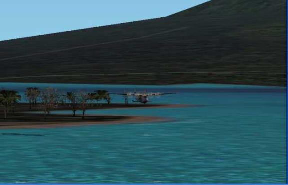
A Clipper arrives at Horta, Azores from Lisbon, Portugal
|
Flight# |
From/To |
ICAO |
Est. Time |
Distance |
|
PA301 |
Lisbon, Portugal Bolama, G-B Africa |
LLSB GGBA |
10:30 |
1651nm |
|
Flight# |
From/To |
ICAO |
Est. Time |
Distance |
|
PA302 |
Bolama G-B Africa Lisbon, Portuga |
GGBA LLSB |
10:30 |
1651nm |
Flights departing Lisbon are reported to the Northern Division,
all other flights listed below are reported to the Southern Division.
I flew the southbound leg with the date set to Dec. 25th (one of the shortest days of the year)
|
Lisbon, Portugal |
NDB 320.0 |
Lv 08:00 |
|
Bolama, G-B Africa |
NDB 759.0 |
Ar 1730 |
Take off was made shortly after sunrise and the landing was shortly before sunset.
I gained an hour enroute with a time zone change. Flight was made at 159 knots.
|
Bolama, G-B Africa |
NDB 759.0 |
Lv 17:30 |
|
Lisbon, Portugal |
NDB 320.0 |
Ar 08:00 |
The northbound trip on the shorter days of the year would have to be flown
at slower speeds so that takeoff and landing could be accomplished in daylight.
In the example above the target ground speed would be 122 knots or less.
On the longer days of the year, perhaps March to mid October it could be flown in daylight, and
the logistics of scheduling the flight for daylight departures and arrivals would be much simpler.
|
Flight# |
From/To |
ICAO |
Est. Time |
Distance |
|
303 |
Bolama, G-B Fisherman’s Lake, Liberia |
GGBA GLFL |
2:35 |
380nm |
|
Flight# |
From/To |
ICAO |
Est. Time |
Distance |
|
304 |
Fisherman’s Lake, Liberia Bolama, G-B |
GLFL GGBA |
2:35 |
380nm |
|
Bolama, G-B |
NDB 759.0 |
Lv 08:00 |
|
Fisherman’s Lake, Liberia |
NDB 753.0 (approach 320.0) |
Ar 11:35 (time zone change) |
PanAm installed an NDB at the eastern edge of Fisherman’s Lake to aid in Zero/Zero Landings. Approach over NDB 320.0 then fly direct to NDB 759.0 at a heading of 309 degrees. Distance is 8.9 nm
|
Fisherman’s Lake, Liberia |
NDB 753.0 |
Lv 14:00 |
|
Bolama, G-B |
NDB 759.0 |
Ar 15:35 (time zone change) |
Visit the B-314 Clipper.com site for more clipper history.
Read the anecdotes submitted by retireed PanAm employees.
|
Flight# |
From/To |
ICAO |
Est. Time |
Distance |
|
401 |
Miami, FL Port of Spain, Trinidad Belem, Brazil Natal, Brazil |
KDIN TTPM SBBS SBNM |
08:55 06:50* 05:20 |
1396nm 1062nm 837nm |
|
Flight# |
From/To |
ICAO |
Est. Time |
Distance |
|
402 |
Natal, Brazil Belem, Brazil Port of Spain, Trinidad Miami, FL |
SBNM SBBS TTPM KDIN |
5:20 06:50* 08:55 |
837nm 1062nm 1396nm |
There is 1 hour time glitch with FS2002 between Port of Spain and Belem. I flew it in 5:47 which is impossible as I was cruising at 158knots The FS2002 log shows 6.8 hours but the GMT clock showed 5:47. So before landing at Belem adjust the clock forward 1 hour, and adjust backward one hour before landing at Port of Spain on the northwest bound leg.
There is a time difference of 1 hour between Belem and Natal, Brazil
|
Miami, FL |
NDB 750.0 |
Lv 07:00 |
|
Port of Spain, Trindad |
NDB 320.0 |
Ar 16:53 Lv 07:00 |
|
Belem, Brazil |
NDB 320.0 |
Ar 14:47 Lv 08:00 |
|
Natal, Brazil |
NDB 754.0 |
Ar 14:20 |
|
Natal, Brazil |
NDB 754.0 |
Lv 06:30 |
|
Belem, Brazil |
NDB 320.0 |
Ar 10:50 Lv 11:50 |
|
Port of Spain, Trindad |
NDB 320.0 |
Ar 17:37 Lv 08:00 |
|
Miami, FL |
NDB 750.0 |
Ar 15:53 |
|
Flight# |
From/To |
ICAO |
Est. Time |
Distance |
|
403 |
Belem, Brazil Bolama, G-B |
SBBS GBBA |
13:42 |
2119nm |
|
Flight# |
From/To |
ICAO |
Est. Time |
Distance |
|
404 |
Bolama, G-B Belem, Brazil |
GBBA SBBS |
13:42 |
2119nm |
|
Belem, Brazil |
NDB 320.0 |
Lv 18:00 |
|
Bolama, G-B |
NDB 759.0 |
Ar 11:16 (time zone change) |
Eastbound flight flown with real weather (15 knot headwinds) 155 kts Time zone changes +2 hours.
|
Bolama, G-B |
NDB 759.0 |
Lv 06:00 |
|
Belem Brazil |
NDB 320.0 |
Ar 17:28 (time zone change) |
Westbound flight flown with zero winds (-2 hour time change) 159kts
|
Flight# |
From/To |
ICAO |
Est. Time |
Distance |
|
405 |
Natal, Brazil Fisherman’s Lake, Liberia |
SBNM GLFL |
10:20 |
1617nm |
|
Flight# |
From/To |
ICAO |
Est. Time |
Distance |
|
406 |
Fisherman’s Lake, Liberia Natal, Brazil |
GLFL SBNM |
10:20 |
1617nm |
|
Natal, Brazil |
NDB 320.0 |
Lv 18:20 |
|
Fisherman’s Lake, Liberia |
NDB 759.0 |
Ar 07:18 |
|
Fisherman’s Lake, Liberia |
NDB 759.0 |
Lv 07:00 |
|
Natal, Brazil |
NDB 320.0 |
Ar 16:10 |
Flown with Real Weather winds at mid point were 120/10
Fisherman’s Lake GMT, Natal GMT-2
Return to the Southern Division Schedules Page