Bluegrass Airlines Headquarters

Links to all Divisions & Hubs
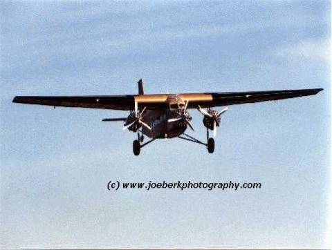
 

*     Pilots Forum

Ford Tri-Motor at Cable Airport  Upland, CA Air Show

Visit www.joeberkphotography.com


Flying the TAT Route

*

The Historical Record

*

Flying the TAT Route

*

TAT Repaint Download

*

The Schedule

*

Navigation

*

TAT Airfields

*

Fs2002 Scenery

Release 05-06-03

*

Fs2002 Scenery – small 17K

update 05-06-03

*

Panel Update

*

The Old Hangar

*

Bluegrass HQ


Del Hopkins developed the TAT Route and Scenery for FS98 Golden Wings by Bill Lyons.

Kevin Breen supplied the historical information.

For FS2002, download the Ford Tri-Motor by Pierino Primavesi

You can find it at avsim.com and flightsim.com  Search for Pierino Ford.

After installing it, download and unzip our Scenery.

Also download Capt. Joe’s repaint!

For FS2002 the scenery is complete. Port Columbus, Indianapolis, St Louis, Kansas City, Wichita, Waynoka, Amarillo, Clovis, Winslow, Kingman and Glendale (LA)  are in the package.  

The 05-06-03 scenery update is a small file that corrects the location of the hangars at Glendale CA.  If you have the scenery from 11-25-02 or the 11-18-02 scenery and the 11-25-02 update just download the 05-06-03 update.

For FS98 download the TAT Routes package and Golden Wings from “The Old Hangar”

For FS2000 try using the FS2002 Scenery, and search flightsim.com for an FS2000 Tri-Motor.  One is available but not in the TAT skin.

If your Ford Tri-Motor has a panel.cfg with a date earlier than 11/2/2002 6:16PM then download the panel update.


THE HISTORY OF TAT

Source Del Hopkins FS98 download file

The Transcontinental Air Transport company was formed to provide a new service for travelers.  They created a special route, using both airplanes and trains, that went coast-to-coast from New York City to Los Angeles.  The reason for both modes of transportation was that the Federal Government refused to allow pasenger air traffic to fly over the Appalachian Mountains at night.  The few navigational aids existing in 1928 consisted of lighted beacons, useless during the day or during fog.  A primitive radio navigation aid consisted of a receiver in an airplane that homed in on a radio frequency that was broadcast from ground stations.  The radio system was not always trustworthy; for instance it was hard to tell whether you were flying toward it or away from it, it was blocked by ground obstructions like mountains and, even worse, the radios of the time didn't always work because of the vibration of the aircraft.  Because of this, the TAT management refused to fly passengers at night.  The only recourse was to place the passengers on trains after dark.

The management worked out plans for the route, and hired Charles Lindbergh to survey the possible routes and oversee construction of necessary airports.  The final route consisted of eleven airports, most of which were existing at the time.  Passengers left New York at the Pennsylvania Station on the Pennsylvania Railroad's "Airway Limited" Pullmans during the night.  The train took them over the Appalacians to the airport at Port Columbus, Ohio, where they arrived in the early morning.  They boarded the TAT planes and flew to Indianapolis, Indiana; St. Louis, Missouri; Kansas City, Missouri; Wichita, Kansas and Waynoka, Oklahoma where they arrived before dark.  TAT took the passengers in a specially made "Aerocar" trailer pulled by a Studebaker roadster to the Harvey House in Waynoka, where they dined.  TAT had built their own station on a siding near the Atchison, Topeka and Santa Fe Railroad station.  After eating, the passengers were transported, via the Aerocar to the TAT station, where they boarded the Santa Fe "Missionary" Pullmans going to Clovis, New Mexico overnight.

The management of TAT worried about the possibility of a late arrival of a plane coming into Waynoka.  In order to keep the passengers from missing the train, they provided a contingency plan.  Between Waynoka, Oklahoma and Clovis, New Mexico, they built a system to catch the train, and to fit their future plans to fly this leg at night, rather than use the railroad.  All along the Santa Fe track, they provided a blinker every three miles, a rotating beacon every ten miles and a lit airport every fifty miles.  Each airport had a station where the night train could be flagged down to board the passengers.

The Clovis airport was next to the railroad station.  The passengers were transported to the TAT terminal there, where they boarded the plane and continued on their way to Albuquerque, New Mexico, Winslow and Kingman, Arizona and finally to Glendale, California, a suburb of Los Angeles.  For passengers continuing on to San Francisco, TAT flew them there for free.

As the flights were expensive, TAT gave the passengers many amenities for their comfort.  Every airport where TAT stopped had an Aerocar to take arriving passengers into town if there flight terminated there.  During the flights, Harvey House hot lunches, as well as snacks, were provided for passengers.  The meals were packed in specially-made Thermos boxes to stay warm during the flights. A steward was aboard every flight to cater to passengers with snacks, pillows, blankets and cotton to place in their ears to dampen the noise of the early airliners.  At each airport the terminal had an adjustable, covered walkway that led from the airplane to the TAT terminal door, and the Aerocar picked them up at the door to take them to the railroad station or to their destination.

TAT bought eleven Ford Trimotors to make up their fleet.  Each plane was named for one of the cities where TAT stopped.  The wicker seats on the Fords were all upholstered for more comfort and had an added headrest for nappers.  The inaugural flight, from both directions, were preceded with announcements and praise from civic leaders and TAT officials to huge crowds.  Food and drink was provided for all.  The planes were on display, as well as the walkways and Aerocars.  This system of travel was brand new, and excited the public.  Most of the passengers were business men who depended upon the speediest travel they could find.  At the time, TAT was the first company to provide coast-to-coast travel that improved the time it took to cross the nation by train.  It cut nearly 24 hours off of the fastest time for trains, which took three days to make the trip.

In October of 1929, the great stock market crash caused TAT's business to begin tapering off until by the summer of 1930, they declared bankruptcy.  A consortium of business men bought the assets of Transcontinental Air Transport, and Trans Western Airways and formed Transcontinental and Western Airways, later to be renamed to Trans World Airlines by owner Howard Hughes.  Although TAT did not last long, it did make airline history by becoming the first transcontinental airline and providing as much comfort as possible for passengers, unheard of in those times.  Throughout its short lifespan, TAT had only one major accident.  In September of 1929, one of their Fords, lost in a fog, flew into the side of Mount Taylor in New Mexico between Albuquerque and Winslow, Arizona.  All aboard were killed.

Back to the Top


Flying the TAT Route

Source Del Hopkin’s FS98 Download

The TAT route was flown using, what is called today, VFR.  Railroads, roads and other familiar landmarks were followed from airport to airport.  All TAT airports had radio stations, broadcasting on the frequencies of the times.  Unfortunately, the radios in the planes were highly undependable at this time.  You can replicate this radio navigation by using an ADF radio.  The radio frequencies used coincided with NDB frequencies.  We suggest you use these aids until you get to know the routes; no use in getting lost.  The radios will not reach all the way along the routes, so we've included some bearings to keep you close to the route until you pick up the radios.  These bearings are for flying east to west.  If you want to fly west to east, just subtract 180 degrees from the bearings. 

In the western half of the route, there are some very tall mountains.  You don't have oxygen and the planes are not pressurized, so you will have to thread your way between peaks, just as the original pilots did.  For authenticity, stay below 10,000 feet above sea level.  That's the top for no oxygen. If you look on a roadmap of the state you are flying through and, in the legend, read the altitude of the highest point in the state, it won't match the altitudes of the mountains in Flight Simulator.  The simulator, in some states, has much higher mountains than can actually be found there.  This especially applies in the west. They cheated you, so if you have to get higher its ok. 

True bearings are much better than magnetic, but with the deviation varying as you travel across the country, you have to recalculate all the time in order to use your compass.  The mag bearings we have included have been tested to keep you on course, at least until you pick up the radio frequency.

Waynoka to Clovis:  TAT built a night route between the Waynoka and Clovis airports, in anticipation of later flying that portion of the route, rather than using the Santa Fe Railroad.  Unfortunately, this portion was never used.  However, we have included it in the route, with a mid stop at Amarillo (radio frequency 290).  You can fly this route at night, if you choose to.  Just stay above 4500 feet on the part between Amarillo and Clovis.  Leave Waynoka steering 240 degrees magnetic, set radio for 290.  The first beacon is about five miles from the airport.

Back to the Top

The Schedule

Source 1929 Consolidated Air Timetables


“Airway LTD”

Miles


Pennsylvania Railroad


“American”

6:05 PM

7:55 AM

0

630

kv

ar


New York City, NY                 (ET)

Port Columbus, OH

ar

lv

9:50 AM

7:46 PM


Transcontinental Air Transport


 8:15 AM

 9:13 AM

 9:28 AM

12:03 PM

12:18 PM

 2:47 PM

 3:02 PM

 4:56 PM

 5:11 PM

 6:24 PM

0

176

176

408

408

631

631

802

802

912

lv

ar

lv

ar

lv

ar

lv

ar

lv

ar

Port Columbus, OH               (ET)

Indianapolis, IN                      (CT)

Indianapolis, IN

St Louis, MO

St Louis

Kansas City

Kansas City, MO

Wichita, KS

Wichita, KS

Waynoka, OK

ar

lv

ar

lv

ar

lv

ar

lv

ar

lv

 7:13 PM

 4:37 PM

 4:22 PM

 2:15 PM

 2:00 PM

11:58 AM

11:43 AM

10:10 AM

 9:55 AM

 8:55 AM

“Missionary”

Miles


A.T. & S.F. Ry


“Scout”

11:00 PM

8:20 AM

0

288

lv

ar

Waynoka, OK

Clovis, NM                              (CT)

ar

lv

8:10 AM

11:35 PM


Transcontinental Air Transport


8:10 AM

10:05 AM

10:20 AM

12:44 PM

12:59 PM

1:51 PM

2:06 PM

4:54 PM

0

191

191

431

431

617

617

897

lv

ar

lv

ar

lv

ar

lv

ar

Portair-Clovis                        (MT)

Albuquerque

Albuquerque, NM

Winslow, AZ

Winslow                                  (MT)

Kingman                                  (PT)

Kingman, AZ

Los Angeles, CA                    (PT)

ar

lv

ar

lv

ar

lv

ar

lv

6:50 PM

4:55 PM

4:40 PM

2:29 PM

2:14 PM

11:33 AM

11:18 AM

8:45 AM

Back to the Top

NAVIGATION

From FS98 Tat Route Download

BGA Flight #

ICAO Codes

From

To

Heading

NDB

Alt

TAT-1

KCMH-KUMP

Port Columbus

Indianapolis

270

220

3,000

TAT-3

KUMP-KSTL

Indianapolis

St Louis

250

320

3,000

TAT-5

KSTL-KMKC

St Louis

Kansas City

270

280

3,000

TAT-7

KMKC-KICT

Kansas City

Wichita

225

345

3,000

TAT-9

KICT-1K5

Wichita

Waynoka

216

300

4,000

TAT-11

1K5-KAMA

Waynoka

Amarillo

230

290

5,000

TAT-13

KAMA-KCVN

Amarillo

Clovis

227

335

5,000

TAT-15

KCVN-???

Clovis

Albuquerque

275

360

7,000

TAT-17

???-KIWN

Albuquerque

Winslow

282

308

8,000

TAT-19

KIWN-KIGM

Winslow

Kingman

280

350

9,000

TAT-21

KIGM-KGND

Kingman

Los Angeles

260

295

9,000

Eastbound flight numbers are even.  KUMP-KCMH is TAT-2

Eastbound flights subtract 180 from Heading and tune in NDB from next line up.

i.e.  Albuquerque to Clovis fly Heading of  95 deg and tune 335.0

Columbus frequency is 295.0

West of Clovis stay below 10,000’ and weave between mountains.


Back to the Top


Here are the TAT airfields for FS2002, in order, from East to West.


STATE

CITY

NDB

LATITUDE

LONGITUDE

ALT.

Ohio

Columbus

304

N39-59.21

W082-52.27

820

Indiana

Indianapolis

220

N39-45.97

W086-12.33

731

Missouri

St. Louis

320

N38-44.35

W090-20.57

610

Missouri

Kansas City

280

N39-07.40

W094-35.57

712

Kansas

Wichita

345

N37-38.96

W097-25.64

1320

Oklahoma

Waynoka

300

N36-34.01

W098-51.14

6001

Texas

Amarillo

518

N35-12.37

W101-42.27

3600

New Mexico

Clovis

335

N34-25.59

W103-04.73

4100

New Mexico

Albuquerque

360

N35-05.22

W106-21.52

6590

Arizona

Winslow

308

N35-01.25

W110-43.48

4940

Arizona

Kingman

350

N35-15.57

W113-56.28

3448

California

Glendale

295

N34-07.90

W118-09.39

804


Back to the Top