

Bluegrass Airlines, September 2007
Pan American Pacific
Clipper Operations
By Bill Von Sennet
|
From |
To |
Heading |
Distance |
NDB |
HF |
Notes |
|
|
Koko Head |
241º |
2076 nm |
KH 316.0 |
|
Waypoint |
|
Koko Head |
|
various |
25nm |
PC 317.0 |
|
Overnite Stop |
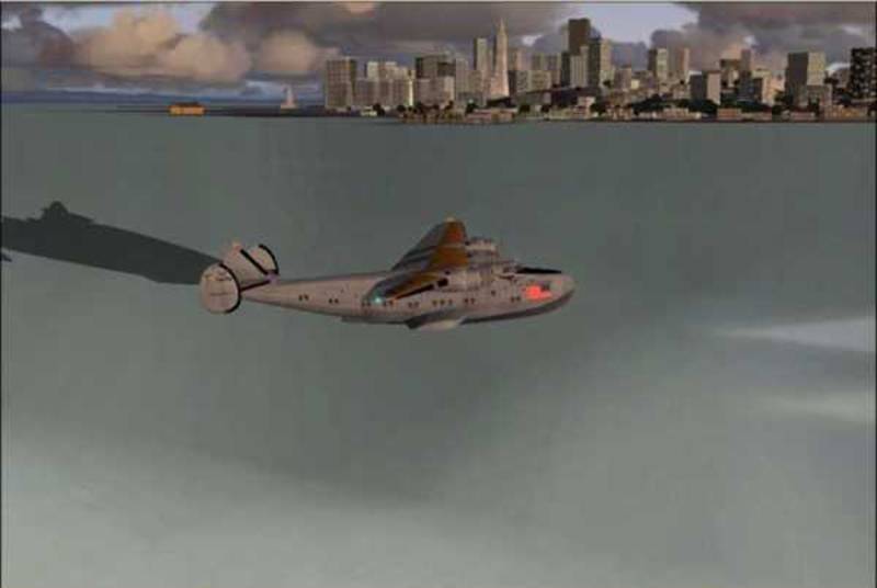
Lift off from
(If I left 16:00
according to the schedule I would arrive at
Koko Head, about to
turn right downwind for
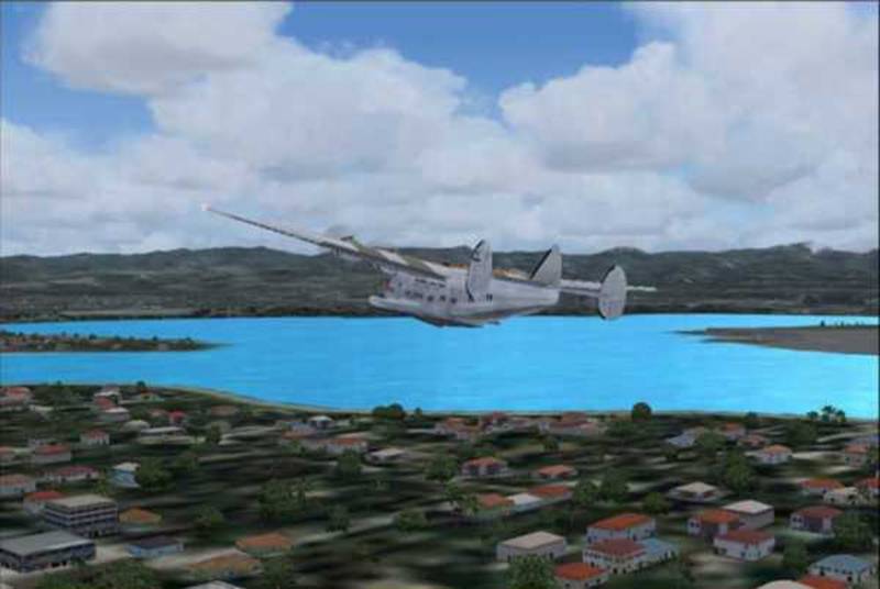
Turning final for
Honolulu SeaBase in
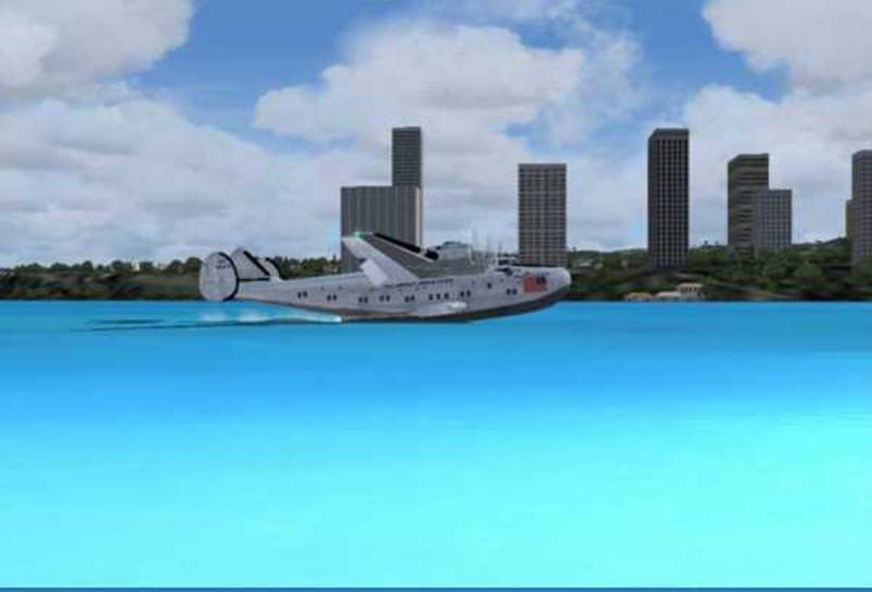
Touching down at
Left San Francisco at
20:00 local (0300z) Arrive Honolulu at
07:30 local (1730z)
Cruised at 135 knots
with real weather. Date set to 18 July 1941.
|
From |
To |
Heading |
Distance |
NDB |
HF |
Notes |
|
|
|
278º |
486 nm |
TI 324.0 |
|
Waypoint |
|
|
|
286º |
650 nm |
MA 325.0 |
Midway 840 |
Overnight Stop |
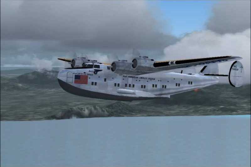
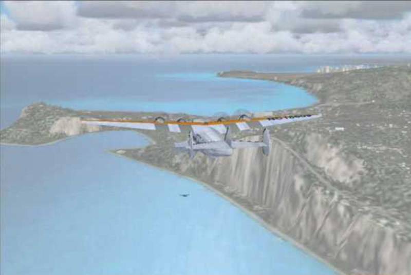
Pacific Clipper
departing
Pacific Clipper on approach
to Midway
I flew this segment according to the FSAviator instructions,
limiting indicated airspeed to 135 knots.
Cruise was at 8,500’ Departure from Honolulu SeaBase was at 8am local
(1800 z). Time over
I won’t bore you with anymore of my flight experiences. Here are the navigation instructions for the
remaining flights.
|
From |
To |
Heading |
Distance |
NDB |
HF |
Notes |
|
|
|
235º |
1029 nm |
WK 326.0 |
Wake 830 |
Overnight Stop |
|
|
|
|
|
|
|
|
|
|
Apra Harbor, |
256º |
1311 nm |
GI 327.0 |
|
Overnite Stop |
|
|
|
|
|
|
|
|
|
|
|
277º |
1374 nm |
ML 328.0 |
|
Overnight Stop |
|
|
|
|
|
|
|
|
|
|
|
320º |
627 nm |
MC 329.0 |
|
Stop |
|
|
|
76º |
36 nm |
HK 330.0 |
|
Destination |
|
|
|
|
|
|
|
|
|
|
Swallow |
225º |
605 nm |
SR 331.0 |
|
Waypoint |
|
Swallow Reef |
|
240º |
694 nm |
WSSB 320.0 |
|
Destination |
|
From |
To |
Heading |
Distance |
NDB |
HF |
Notes |
|
|
Swallow |
59º |
694 nm |
SR 331.0 |
|
Waypoint |
|
Swallow Reef |
|
45º |
605 nm |
ML 328.0 |
|
Overnight Stop |
|
|
|
|
|
|
|
|
|
|
|
256º |
36 nm |
MC 329.0 |
|
Stop |
|
|
|
137º |
627 nm |
ML 328.0 |
|
Overnight Stop |
|
|
|
|
|
|
|
|
|
|
Apra Harbor, |
88º |
1374 nm |
GI 327.0 |
|
Overnight Stop |
|
|
|
|
|
|
|
|
|
|
|
64º |
1311 nm |
WK 326.0 |
Wake 830 |
Overnight Stop |
|
|
|
|
|
|
|
|
|
|
|
46º |
1029 nm |
MA 325.0 |
Midway 840 |
Overnight Stop |
|
|
|
|
|
|
|
|
|
|
|
100º |
650 nm |
SR 331.0 |
|
Waypoint |
|
|
|
95º |
486 nm |
PC 317.0 |
|
Overnight Stop |
|
|
|
|
|
|
|
|
|
|
Koko Head |
104º |
16nm |
KH 316.0 |
|
Waypoint |
|
Koko Head |
|
38º |
2076 nm |
TI 318.0 |
Treasure I 820 |
Destination |
|
From |
To |
Heading |
Distance |
NDB/VOR |
HF |
Notes |
|
|
13 nm W of |
225º |
16 nm |
|
|
Waypoint |
|
13 nm W of |
23 nm W of
|
214º |
140 nm |
|
|
Waypoint |
|
23 nm W of |
San Pedro |
95º |
137 nm |
SPD 319.0 |
San Pedro 850 |
Enroute Stop |
|
San Pedro |
Koko Head |
250º |
2212 nm |
CKH 113.90 |
|
Waypoint |
|
Koko Head |
|
various |
25 nm |
PC 317.0 |
|
Overnite Stop |
|
|
|
|
|
|
|
|
|
|
|
186º |
960 nm |
PA 321.0 |
|
Waypoint |
|
|
|
218° |
779 nm |
CI 322.0 |
|
Overnight Stop |
|
|
|
|
|
|
|
|
|
|
Rotumwa, F.I. |
217º |
883 nm |
RM 323.0 |
|
Waypoint |
|
Rotumwa F.I. |
|
212º |
846 nm |
NWSB 320.0 |
|
Overnight Stop |
|
|
|
|
|
|
|
|
|
|
|
154º |
412 nm |
NF 260.0 |
|
Waypoint |
|
|
|
127º |
591 nm |
NZAB 320.0 |
Auskland 700 |
Destination |
|
From |
To |
Heading |
Distance |
NDB |
HF |
Notes |
|
|
|
307º |
591 nm |
NF 260.0 |
|
Waypoint |
|
|
|
336° |
412 nm |
NWSB 320.0 |
|
Overnight Stop |
|
|
|
|
|
|
|
|
|
|
Rotumwa, F.I. |
036º |
846 nm |
RM 323.0 |
|
Waypoint |
|
Rotumwa F.I. |
|
039º |
883 nm |
CI 322.0 |
|
Overnight Stop |
|
|
|
|
|
|
|
|
|
|
|
038º |
779 nm |
PA 321.0 |
|
Waypoint |
|
|
|
003º |
960 nm |
PHSB 320.0 |
|
Destination |
|
|
|
|
|
|
|
|
|
|
Koko Head |
104° |
16 nm |
CKH 113.90 |
|
Waypoint |
|
Koko Head |
|
048º |
2212 nm |
KSPD 319.0 |
San Pedro 850 |
Enroute Stop |
|
|
23 nm W of |
275º |
137nm |
|
|
Waypoint |
|
23 nm W of |
13 nm W of |
320º |
214 nm |
|
|
Waypoint |
|
13 nm W of |
|
44º |
16 nm |
TI 318.0 |
Treasure I 820 |
Destination |
It has been over 5 years since Bill Odell and I created the “The
Clipper” featuring the Pan American Trans-Atlantic Routes.
In the interim, we have new aircraft and flight dynamics
available. The finest Boeing 314
Clipper is a payware product from Pilot’s http://www.b314clipper.com/indexA.htm
It comes complete with a scenery package that included many PanAm
bases along the Pacific and Atlantic Routes.
They include long range radio direction finders. All the bases for the
In order to be able to use the HF Direction Finder at additional
bases:
Midway (freq. 840)
San Pedro CA (freq. 850)
I added these five lines to the
PILOTS_B314_dfstations.dat file located in the main Flight Simulator 9
folder:
28.220278;-177.371944;840;0;Midway;
33.728056;-118.278056;850;0;San Pedro;
22.211389;113.541944;860;0;
22.323333;114.203889;870;0;
1.426667;103.895000;880;0;
Flights using the Pilots B-314 or B-314A will not use the NDB’s and
the waypoints shown above. They will fly
direct using the HF Direction Finder.
If 39.95 eur is a bit steep
for you, there are freeware alternatives.
Mike Stone’s B314 is on our server.
Download sb314.zip
The Pacific Clipper textures by Wayne Tudor and Dale Deluca are
available at www.avsim.com filename is paab314.zip (1.2 mb)
The Yankee Clipper textures by Wayne Tudor and Dale Deluca are
available at www.avsim.com filename is
paa_yc.zip (1.3 mb)
The BOAC Clipper textures by Wayne Tudor and Dale Deluca are
available at www.avsim.com filename is
boacb314.zip (1.2 mb)
Panel by Ken Mitchell is at www.avsim.com filename is b314km_panel.zip (9.9 mb)
Get the updated B-314 flight dynamics by Bob Chicilo. Filename is
b314up.zip (39k) available at www.flightsim.com
The manifold
pressure does not indicate correctly. (cruise is at about 15”) I fly cruise at 1700 rpm and decrease
throttle as fuel is burned to maintain 110 knots. The only change I made to the aircraft.cfg
file is to change fuel_flow_scalar to 0.80
This results
in performance similar to the actual schedule times.
For those that don’t have the Pilots B-314
package, scenery is available, although the locations may differ.
Download the
float base scenery from the Bluegrass FS 2004 Hangar Scenery section. It has all the NDB’s needed to fly the PanAm
Pacific routes. If you already have the
Float Base Scenery then just download the panam_pacific.zip file which contains
the NDB’s.
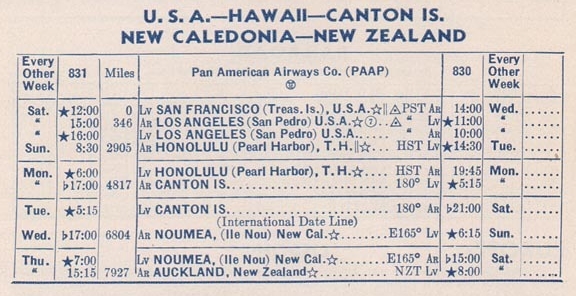
Pan American
only flew the
The Boeing 314
was turned at
I flew these
flights at 16x while at cruise altitude.