Bluegrass Airlines Feature of the
Month
May 2011
Bahamas
Airways ‘59
by
Allan Lowson
(copyright
www.timetableimages.com)
Bahamas Airways
Bahamas
Airways Ltd was founded in 1936 to take over
the operation of inter-island charter services begun in 1933.
In 1943, Pan American Airways acquired a 45 per cent interest in the company
but in 1949 Bahamas Airways was taken over by BSAA and later became a wholly
owned BOAC subsidiary. In April 1959
BOAC sold 80 per cent of its shareholding to Skyways Bahamas Holding Co Ltd,
but in December 1960 the Corporation bought back this holding.
In March
1956 Bahamas Airways inaugurated a service to Grand Turk, Turks Island via San
Salvador Island, Mayaguana and Great Inagua.
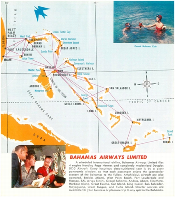
Bahamas Airways Routes
Bahamas
Airways served routes throughout the islands as well as international routes to
Florida. In '59 the inter-island services were provided by DC-3 or Grumman
Goose aircraft. The routes from Miami to Nassau were covered by the Handley
Page Hermes and DC-3s.
The
Hermes were especially modified for the routes to Florida, increasing seating
capacity to 78 and removing the pressurisation equipment to allow for a more
luxurious passenger compartment. However the Hermes struggled to attract
American customers, basically because they did not recognise them! After BOAC
bought the airline back from Skyways
they introduced Vickers Viscounts with more success.
The
times for these flights are taken from the 1959 timetable available at the
excellent www.timetableimages.com
Miami – West Palm Beach – Ft Lauderdale –
Nassau
These services served
flown by Handley Page Hermes aircraft.
|
Heading |
Distance |
Down |
City Name |
ICAO |
Up |
Heading |
Distance |
|
105 |
0 |
1015 |
Miami
|
KMIA |
0930 |
|
160 nm |
|
|
160nm |
1115 |
Nassau |
MYNN |
0830 |
287 |
0 |
|
Heading |
Distance |
Down |
City Name |
ICAO |
Up |
Heading |
Distance |
|
186 |
0 nm |
1000 |
West
Palm Beach |
KPBI |
2100 |
|
37nm |
|
112 |
37nm |
1040 |
Ft
Lauderdale |
KFLL |
2030 |
006 |
159nm |
|
|
159nm |
1140 |
Nassau |
MYNN |
1930 |
293 |
0 |
Nassau – Harbour Island (Eleuthera
Island)
This route was served
by Douglas DC-3 aircraft.
|
Heading |
Distance |
Down |
City Name |
ICAO |
Up |
Heading |
Distance |
|
096 |
0 |
1545 |
Nassau
|
MYNN |
1040 |
|
70nm |
|
338 |
70nm |
1635 |
Rock
Sound |
MYER |
1005 |
276 |
25nm |
|
300 |
25nm |
1705 |
Governor's
Harbour
|
MYEM |
0935 |
158 |
22nm |
|
237 |
22nm |
1725 |
Harbour
Island |
MYEH |
0900 |
119 |
0 |
|
|
50nm |
1815 |
Nassau
|
MYNN |
|
|
|
Nassau – Turks Island
This route was served
by Douglas DC-3 aircraft.
|
Heading |
Distance |
Down |
City Name |
ICAO |
Up |
Heading |
Distance |
|
138 |
0 |
0745 |
Nassau
|
MYNN |
1645 |
|
320nm |
|
078 |
320nm |
1130 |
Inagua |
MYIG |
1425 |
319 |
144nm |
|
|
144nm |
1230 |
Turks
Island |
MBGT |
1250 |
259 |
0 |
Nassau – Great Exuma
– San Salvador Island
This route was served
by Douglas DC-3 aircraft, note this is a circular route.
|
Heading |
Distance |
Down |
City Name |
ICAO |
Up |
Heading |
Distance |
|
135 |
0 |
1245 |
Nassau
|
MYNN |
1615 |
|
700nm |
|
062 |
131nm |
1400 |
George
Town (GE) |
MYEG |
|
|
|
|
|
78nm |
1440 |
San
Salvador |
MYSM |
1455 |
290 |
78nm |
|
|
|
|
George Town (GE) |
MYEG |
1400 |
062 |
0 |
Nassau – Great Abaco – Grand Bahama – Florida
This route was served
by Douglas DC-3 aircraft. Freeport is a flag stop, so it is included without a
time. This is a circular route.
|
Heading |
Distance |
Down |
City Name |
ICAO |
Up |
Heading |
Distance |
|
012 |
0 |
1245 |
Nassau
|
MYNN |
1635 |
|
91nm |
|
309 |
91nm |
1400 |
Marsh
Harbour |
MYEG |
1550 |
192 |
22nm |
|
260 |
22nm |
1440 |
Green
Turtle Cay |
MYSM |
1520 |
129 |
71nm |
|
298 |
71nm |
F |
Freeport |
MYGF |
F |
080 |
16nm |
|
240 |
16nm |
1140 |
West
End (GB) |
MYGW |
1410 |
118 |
61nm |
|
006 |
74nm |
1245 |
Ft
Lauderdale |
KFLL |
- |
- |
- |
|
|
37nm |
1305 |
West
Palm Beach |
KPBI |
1320 |
089 |
37nm |
|
|
|
|
Ft Lauderdale |
KFLL |
1245 |
006 |
|
Nassau – Cat Island
This route was served
by Grumman Goose aircraft, and is again a circular route.
|
Heading |
Distance |
Down |
City Name |
ICAO |
Up |
Heading |
Distance |
|
103 |
0 |
1230 |
Nassau
|
MYNN |
1510 |
|
117nm |
|
148 |
100nm |
1335 |
Bennetts
Harbour |
MYCA |
|
|
|
|
|
22nm |
1355 |
The
Bight |
MYCB |
1405 |
291 |
0 |
Nassau – Mangrove Cay
This route was served
by Grumman Goose aircraft.
|
Heading |
Distance |
Down |
City Name |
ICAO |
Up |
Heading |
Distance |
|
196 |
0 |
1230 |
Nassau
|
MYNN |
1510 |
|
47nm |
|
|
22nm |
1355 |
The
Bight |
MYAB |
1405 |
016 |
0 |
Nassau – Andros Town
This route was served
by Grumman Goose aircraft.
|
Heading |
Distance |
Down |
City Name |
ICAO |
Up |
Heading |
Distance |
|
272 |
0 |
1300 |
Nassau
|
MYNN |
1350 |
|
33nm |
|
147 |
33nm |
F |
Mastic
Point |
MYAN |
F |
91 |
25nm |
|
|
25nm |
1320 |
Andros
Town |
MYAF |
1330 |
327 |
0 |
Flight Simulator Files
There is a Handley Page Hermes by Jens Kristensen available for both FS2004 and FSX in Hermes_v20.zip
and Hermes_v20x.zip respectively. Jens very kindly
agreed to do a Bahamas
Airways scheme for the Hermes and this can be found in hp81_bahamas_fs9.zip and hp81_bahamas_fsx.zip
from www.flightsim.com
Although the DC-3 is not available in an
Bahamas Airways scheme, John Payne did a Skyways Coach-Air set of schemes, and
the Skyways AirCoach scheme is closest to that used
by Bahamas Airways at the time of these flights; these are available in
skwydc3s.zip from www.flightsim.com .
Jens has also done the Vickers Viscount which
was introduced by BOAC after they re-purchased the company, and this package includes
a Bahamas Airways scheme. The package is available in Viscount_10.zip and
Viscount_10x.zip.
The Grumman Goose is available in a package
by Bill and Lynn Lyons in cc9g21f.zip for fs2004.
The flights are covered by the default
scenery, but the Bahamas can be significantly enhanced for fs2004 if you add
the bahamas add-on scenery package available at www.fs-freeflow.com.