This month's
hop list is a tour of seaplane bases around and about Prince of Wales Island in Alaska.
So pack your fishing rods or take a kayak to splash around the bays if spearing
worms with hooks leaves you cold.
From www.travelalaska.com we hear that at 140 miles long
and more than 2,230 square miles, Prince of Wales Island is the third-largest island in
the USA, after Alaska's Kodiak Island and Hawaii's Big Island. A three-hour ferry
ride from Ketchikan, Prince of Wales Island is a vast, rugged island, the perfect
destination for adventurous visitors who come to Alaska with a paddle or backpack in hand
or with hopes of landing a trophy salmon or halibut.
The 990-mile coastline of
Prince of Wales Island meanders around numerous bays, coves, saltwater straits and
protected islands, making it a kayaker's delight. Chains of inland lakes are better
suited for paddlers willing to portage a canoe, and the island is scattered with U.S.
Forest Service cabins for those who want to spend a night on their own in the wilderness.
The island has the most extensive road system in the Inside Passage, with 1,300
miles of paved or maintained gravel roads that lead to small villages, rustic camping
grounds, fishing lodges and numerous trails. There are also several hundred miles of
logging roads that many visitors explore on mountain bikes.
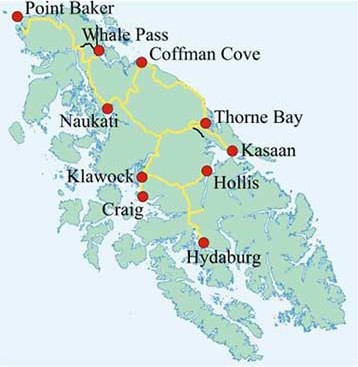
Once on the island, visitors
can head off to a dozen small communities with most offering accommodations and other
services. Hollis, population 172, is where the Inter-Island Ferry docks. The
largest towns best equipped to handle visitors are Craig, population 1,117, and Klawock,
population 785, only seven miles apart but still a 31-mile drive across the island along
the paved Hollis-Klawock Highway. Also supporting lodging, restaurants, small
grocery stores and other visitor amenities is Thorne Bay, population 440, 38 miles
northeast from Klawock, and Coffman Cove, population 141, 55 miles north of Klawock.
Prince of Wales Island now has 150 miles of paved roads that connects all five of
these towns.
We start off from Klawock and
end up back at the same seaplane port. As there is no indication of the location of
seaplane bases apart from the symbol on the maps, it is advisable to select a
seaplane/floatplane/amphibian aircraft with GPS to help find the approximate location.
Apart from that, just fly whatever floats your boat from a Piper Cub on up, as they
say.
Prince of Wales
Island Hop List
Heading |
Distance |
Airfield
Name |
ICAO |
| 202 |
0 |
Klawock |
AQC |
196 |
4.5 |
Craig |
CGA |
110 |
11.4 |
Waterfall |
KWF |
020 |
15.2 |
Hydaburg |
HYG |
068 |
17.6 |
Hollis |
HYL |
332 |
9.1 |
Kasaan |
KXA |
071 |
10.2 |
Thorne
Bay |
KTB |
308 |
10.0 |
Meyers
Chuck |
84K |
306 |
25.3 |
Coffman
Cove |
KCC |
192 |
11.6 |
North
Whale |
96Z |
327 |
16.4 |
Nickin
Cove |
AK62 |
276 |
6.2 |
Tokeen |
57A |
147 |
15.9 |
Cape
Pole |
Z71 |
186 |
12.8 |
Port
Alice |
16K |
088 |
15.4 |
Steamboat
Bay |
WSB |
| - |
18.0 |
Klawock |
AQC |
|