

January 2007
Union Airways of New Zealand 1936-1937 by Bill Von Sennet
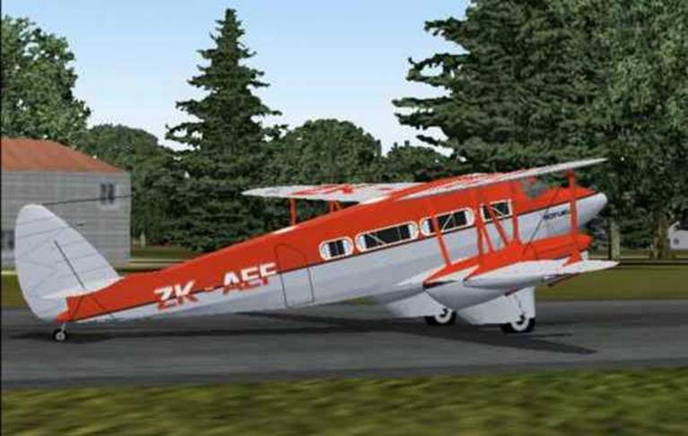
Dh.86 de Havilland
Express ready for takeoff at Wigram Field,
For the 1936
flights we have Lee Holmes Dh.86 Express
Download CLH_DH86Express.ZIP (2.3mb)
For the 1937 flights I used the FS Design Berlin L-10A Electra by Arik
Hohmeyer filename l104nwa.zip (12.3mb)
and the Union Airways textures by Dale DeLuca and Arik Hohmeyer filename
l104uni.zip (1.3mb) Both are available
at www.avsim.com and www.flightsim.com
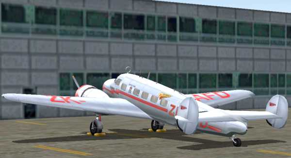
Union Airways
Lockheed L-10A Electra ZK-AFD at Palmerston North
On 16-March 1936 Union Airways started regular air mail service between
Palmerston North, Blenheim,
On 27-June 1937 Union Airways began mail service between
On 1-July 1937 Union Airways took over the East Coast Airways route
between Palmerston North, Napier and Gisborne
The information above was found on Robert Clark’s web-site: New Zealand Stamp Images
Article
on early aviation in the Encyclopedia of New Zealand
By
1939 Union Airways was maintaining
services on these routes:
Auckland–New
Plymouth–Palmerston North–Wellington–Christchurch–Dunedin
Palmerston
North–Blenheim–Christchurch
Palmerston
North–Napier–Gisborne
Auckland–Tauranga–Opotiki–Gisborne.
1936 Flights
|
City |
Airport |
ICAO |
Heading |
Distance |
To Waypoint |
Navaid |
|
|
|
NZPM |
198° |
45.5 nm |
Paraparaumo |
PP 242.0 |
|
|
|
|
188° |
15.8 nm |
|
TY 234.0 |
|
|
|
|
214° |
42.4 nm |
Blenheim |
BM 342.0 |
|
|
|
|
241° |
5.8 nm |
Woodbourne |
WB 366.0 |
|
Blenheim |
Woodbourne Mil. |
NZWB |
246° |
1.1 nm |
Runway 25 |
|
|
City |
Airport |
ICAO |
Heading |
Distance |
To Waypoint |
Navaid |
|
Blenheim |
Woodbourne Mil. |
NZWB |
104° |
21.9 nm |
|
CC 286.0 |
|
|
|
|
190° |
48.5 nm |
Kaikoura |
KI 350.0 |
|
|
|
|
195° |
83.1 nm |
Woodend |
OD 262.0 |
|
|
|
|
173° |
10.3nm |
Fix 217° to BU |
BU 374.0 |
|
|
Wigram |
NZWG |
210° |
4 nm |
Runway 21 |
|
|
City |
Airport |
ICAO |
Heading |
Distance |
To Waypoint |
Navaid |
|
Chirstchurch |
Wigram |
NZWG |
213° |
39.1 nm |
Ashburton |
AS 254.0 |
|
|
|
|
203° |
34.9 nm |
Timaru |
TU 366.0 |
|
|
|
|
162° |
38.5 nm |
Oamaru |
OU 302.0 |
|
|
|
|
184° |
58 nm |
Swampy |
SW 338.0 |
|
|
|
|
212° |
7.9 nm |
Mosgiel |
MI 358.0 |
|
|
|
NZDN |
212° |
5.7 nm |
Runway 21 |
|
Hypothetical
1936 Schedule Dh. 86 Express
|
Down |
|
|
|
Up |
|
8:30am |
Lv |
Palmerston North |
Ar |
2:20pm |
|
9:25am |
Ar |
Blenheim |
Lv |
1:25pm |
|
9:45am |
Lv |
Blenheim |
Ar |
1:05pm |
|
11:05pm |
Ar |
|
Lv |
11:45am |
|
11:50am |
Lv |
|
Ar |
11:00am |
|
1:20pm |
Ar |
Dundedin |
Lv |
9:30am |
1937
Flights
|
City |
Airport |
ICAO |
Heading |
Distance |
To Waypoint |
Navaid |
|
|
|
NZAA |
173° |
123.6 nm |
|
|
|
New |
New |
NZNP |
|
|
|
NP 114.40 |
|
City |
Airport |
ICAO |
Heading |
Distance |
To Waypoint |
Navaid |
|
New |
New |
NZNP |
119° |
103.5 |
|
|
|
Palmerston North |
Palmerston North |
NZPM |
|
|
|
PM 113.40 |
|
City |
Airport |
ICAO |
Heading |
Distance |
To Waypoint |
Navaid |
|
Gisbourne |
Gisbourne |
NZGS |
206° |
70.2 nm |
|
|
|
Napier |
Napier |
NZNR |
|
|
|
NR 113.80 |
|
City |
Airport |
ICAO |
Heading |
Distance |
To Waypoint |
Navaid |
|
Napier |
Napier |
NZNR |
206° |
76.9 nm |
|
|
|
Palmerston North |
Palmerston North |
NZPM |
|
|
|
PM 113.40 |
|
City |
Airport |
ICAO |
Heading |
Distance |
To Waypoint |
Navaid |
|
Palmerston North |
Palmerston North |
NZPM |
190° |
71.5 nm |
|
|
|
|
|
NZWN |
|
|
|
WN 112.30 |
|
City |
Airport |
ICAO |
Heading |
Distance |
To Waypoint |
Navaid |
|
|
|
NZWN |
167° |
194.0 nm |
|
CH 115.30 |
|
|
|
NZCH |
|
|
ILS RW20 |
IHW 110.30 |
|
City |
Airport |
ICAO |
Heading |
Distance |
To Waypoint |
Navaid |
|
|
|
NZCH |
187° |
162.6 nm |
Swampy |
SW 112.70 |
|
|
|
|
211° |
13.7 nm |
|
|
|
|
|
NZDN |
|
|
ILS RW21 |
IDN 109.90 |
Hypothetical
1937 Schedule Lockheed L-10A Electra
|
Down |
Down |
|
|
|
Up |
Up |
|
6:30pm |
|
Lv |
|
Ar |
6:10pm |
|
|
7:30pm |
|
Ar |
New |
Lv |
5:10pm |
|
|
7:40pm |
|
Lv |
New |
Ar |
5:00pm |
|
|
|| |
7:00am |
Lv |
Gisbourne |
Ar |
|| |
5:30pm |
|
|| |
7:35am |
Ar |
Napier |
Lv |
|| |
4:55pm |
|
|| |
7:45am |
Lv |
Napier |
Ar |
|| |
4:45pm |
|
8:30pm |
8:20am |
Ar |
Palmerston
North |
Lv |
4:10pm |
4:10pm |
|
|
8:30am |
Lv |
Palmerston
North |
Ar |
4:00pm |
|
|
|
9:05am |
Ar |
|
Lv |
3:25pm |
|
|
|
9:15am |
Lv |
|
Ar |
3:15pm |
|
|
|
10:30am |
Ar |
|
Lv |
2:00pm |
|
|
|
10:40am |
Lv |
|
Ar |
1:50pm |
|
|
|
11:59am |
Ar |
|
Lv |
12:30pm |
|
Airport Information
Runways 5L
10,195’ Bitumimus ILS ISL 110.10
23R 10,195’ Bituminus ILS ITR 109.50
5R 11,926’ Concrete ILS IAA 110.30
23L 11,926’ Concrete ILS IMG 109.90
VOR/DME 114.80
New
Runways 5/23 4,295’ Bituminus
5R/23L 2,300’ Dirt
14/32 3.940’ Grass
VOR/DME
114.40
NDB 370.0
Gisbourne NZGS elev 15’
Runways
3/21 3,772’ Gravel
9/27 3,838’ Gravel
14/32 4,298 Bituminus
VOR/DME 114.20
NDB 346.0
Napier NZNR elev 6’
Runways 7/25 3,993’ Grass
10/28 1,605’ Grass
16/34 4,927’ Bituminus
16L/34R 2,513’ Grass
VOR/DME 113.80 0.7nm North on RW 16 Final
NDB 354.0
North Palmerston NZPM elev 150’
Runways
7/25 6,272’
Bituminus
7R/25L
1,995’ Grass
VOR/DME 113.50
NDB 258.0
Runways 16 6,762’ Asphalt ILS IEB 110.30
34
6,672’
Asphalt ILS IMP 109.90
VOR/DME 112.30
NDB 298.0
Woodbourne (Military) NZWB elev 108’
Runways 10/28 3,878’ Gravel
7/25 4,668’ Bituminus
VOR/DME 115.60
NDB 366.0 (1.1 nm at 66°)
Christchurch Intl NZCH elev
121’
Runways 2 10,781’ Asphalt ILS ICH
109.90
20
10,781’
Asphalt ILS IHW 110.30
11/29 5,680’ Asphalt
VOR/DME 115.30
NDB
262.0 12.7nm Final RW 20
NDB
374.0 8.7nm Final RW 2
Wigram NZWG elev 75’
Runways 3/21 5,184’ Bituminus
6/24 4,767’ Grass
13/31 3,888’ Grass
18/36 3,215’ Grass
VOR/DME 115.30 (3.3 nm at 306°)
Runways 3 6,295’ Asphalt
ILS IHL 110.30 32°
DME
115.70 NDB 378.0 (1.3 nm final RW3)
21 6,295’ Asphalt ILS IDN 109.90 212°
VOR/DME
112.70 (13.7 nm final RW21)
NDB 358.0 (5.7 nm final RW21)