|
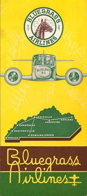
Bluegrass Airlines
was started by a Bowling Green, Kentucky, doctor and his two sons in
1944. It was one of the first post war intra-state carriers.
The company ceased operations in the fall of 1946.
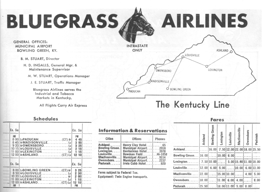
In 1946, the
Central Time Zone was used for all of Kentucky. Currently,
Louisville, Lexington and Ashland observe Eastern Time.
|
Heading |
Distance |
Read Down |
Read Down |
|
|
Time Zone |
|
Read Up |
Read Up |
Heading |
Distance |
| 255 deg |
93.3 nm |
|
1:10 |
Lv |
Ashland, KY |
ET |
Ar |
1:00 |
|
|
|
| 286 deg |
51.0
nm |
|
2:15 |
Lv |
Lexington,
KY |
|
Lv |
11:59 |
|
75 deg |
93.3 nm |
| |
|
|
3:00 |
Ar |
Louisville, KY |
|
Lv |
11:20 |
|
106 deg |
51.0
nm |
| 207 deg |
83.9 nm |
3:30 |
|
Lv |
Louisville, KY |
ET |
Ar |
|
9:50 |
|
|
| |
|
3:25 |
|
Ar |
Bowling
Green, KY |
CT |
Lv |
|
8:00 |
27 deg |
83.9 nm |
| 249 deg |
76.9 nm |
|
3:15 |
Lv |
Louisville, KY |
ET |
Ar |
11:15 |
|
|
|
| 206 deg |
25.6
nm |
|
3:25 |
Lv |
Owensboro, KY |
CT |
Lv |
9:20 |
|
69 deg |
76.9 nm |
| 254 deg |
68.0
nm |
|
3:55 |
Lv |
Madisonville, KY |
|
Lv |
8:45 |
|
26 deg |
25.6
nm |
| |
|
|
4:45 |
Lv |
Paducah,
KY |
CT |
Lv |
8:00 |
|
74 deg |
68.0
nm |
Airport Info
KDWU –
Ashland-Boyd Co. – Elevation 544’
Runways 10/28, ILS RWY
10, 108.90, ILS/BC RWY 28, 108.90
YRK VOR/DME, 112.80, 50 nm
range, located 12.5 nm WNW 300 deg
KLEX –
Lexington Blue Grass – Elevation 977’
Runways 04/22 and
08/26, ILS/GS RWY 04, 110.10, ILS/GS RWY 22, 110.50
HYK VOR/DME,
112.60, 60 nm range, located 7.7 nm ESE 122 deg
LE NDB, 242.0, 38
nm range, located 3.3 nm on final for RWY 04
KLOU
– Louisville Bowman – Elevation 548’
Runways 01/19,
06/24 and 14/32
BQM VOR/DME, 112.20, 38 nm range, located on
field
LIU VOR/DME, 114.80, 195 nm range, located 8.5 nm S 153 deg
LK NDB, 414.0, 38 nm range, located 5.2 nm S 166 deg.
KBWG – Bowling Green-Warren Co. Regl – Elevation 547’
Runways 03/21 and 12/30, ILS/GS RWY 03, 108.75, ILS/BC RWY
21, 108.75
BWG VOR/DME, 117.90, 195 nm range, located 2.4 nm SSW
209 deg
BW NDB, 238.0, 38 nm range, located 5.5 nm on final for
RWY 03.
KOWB – Owensboro-Daviess Co. – Elevation
406’
Runways 05/23 and 18/36, ILS/GS RWY 36, 111.50,
ILS/BC RWY 18, 111.50
OWB VOR/DME, 108.60, 38 nm range, located
on field
2I0 – Madisonville – Elevation 439’
Runways 05/23
CCT VOR/DME, 109.80, 60 nm range,
located 6.7 nm E 76 deg
KPAH – Paducah Barkley
Regl. – Elevation 410’
Runways 04/22 and 14/32, ILS/GS
RWY 04, 108.50, ILS/BC RWY 22, 108.50
CNG VOR/DME, 113.10, 60 nm
range, located 3.8 nm final for RWY 04
BDD NDB, 254.0, 38 nm
range, located on 6.6 nm final for RWY 22
Flight Simulator Files
The
aircraft flown was a Cessna T-50 'Bobcat'.
There is a Cessna T-50
'Bobcat' by Alphasim available for FS2004 from the Virtavia freeware
site
www.virtavia.com/Freeware/index.php.
This aircraft will
fly in FSX, but all of the gauges will have to be replaced with FSX
gauges. A revised panel for FSX and a repaint in Bluegrass Airlines
livery is
available
HERE.
|