Bush Pilots
Division
by Bill
Odell
First Tough Man
Challenge
When Capt Brent asked me to do
the Tough Man Challenge, he only had a few “understandings” (we don’t use
rules). The season had to be winter, it shouldn’t be too long, had
to have challenges but not impossible for even the neophytes that might be
amongst us, you can use the; NDB; DME; VOR, you cannot use the ILS or GPS. Selecting a starting point was a challenge
in itself since I wanted to get a bit of as many types of areas that a Bush
Pilot would fly in. Then came the
aircraft selection and we both agreed almost at once that it had to be the
“Otter”. What are the challenges then?
I have decided to bring them up in each leg as you fly. So where do we start, my choice is PAPH -
Port Heiden. I will lull you into a
false sense of security with the first leg.
Most of the flights and routes you probably have never heard of or
flown, that is great. You can fly as
many flights in a day as you desire as there is no set time, but the longer you
take the longer Capt. Brent has to slave over the barbecue with his specialty
“Barbecue Caribou”. Those with the most goofs will have to be bus boys.
So with out any further ado lets get in the air.
Before you
get airborne, I would like to make a suggestion, print this out and follow the
narration as you fly, it might save an embarrassing situation.
PAPH to PAIL. As we are flying during the winter our flying days start a little
later, so take off from Port Heiden for Iliamna at 10:00. The altitude I selected is 3500' as I didn’t
want this to be a <Yawn> flight.
There is not too much of a challenge on this leg, just enough to get you
ready for what lies ahead. This will be
one of the longer legs of the challenge about 210nm. Most of our flights will be in the 1-hour range.
PAIL - PASX.
Here I am going to set a maximum altitude rather than a set altitude for
the flight. I flew this at 3500' and
was able to have fun flying the valleys and passes without the knuckles getting
too white. There are places that you
can get lower than that. The last sixty
miles you can get down on the deck as it is over water to Soldotna.
PASX - PASW. This is a rather short leg and
we will be flying at 4500'. Just look
at those snow covered mountains ahead, don’t worry we will not reach them with
this leg, but you will have to fly through them soon. Note I said through not over.
Now for those that haven’t had any problem with this leg at 4500', are
you aware that at quite a few points you only had 10' or 20' ground clearance,
for those who heard a “Scrunch” better start paying attention, don’t let me
lull you asleep here. That faint glimmer to left there is Skwetna; the bright
light is the waterfalls.
PASW -PAMH. Hell of a thing to stare you in
the face as you climb out. I followed a
river or was it a lake that led me to a series of valleys and a pass that I was
able to negotiate at 7500'. It took a
lot of turning and twisting but I did it and do not recommend it, suggest
8500'. Well through the pass and all
downhill from here to Minchumina. Pay
attention to your descent you don’t want to get to approach altitude too early
as viz is poor during the winter. Ah
there is the strip - Minchumina you don’t land short and you don’t land long
unless you are in a Goose and time your retraction of the landing gear at the
exact second or “Kersplash”.
PAMH - PABT. There are mountains between
Minchumina and Bettles that get up to 6000'.
With the full load, and if the truth be known you are probably over
gross, to keep the strain off the engine climbing to a high altitude we will
fly this leg at what seems to be my favorite altitude, 3500'. Now if we set a course for Tanana and take a
heading of 340 out of there we are going to be in the general direction of a
pass that I use (I fly this region quite often), just be careful and keep the
high stuff off your right wing. Through
the pass, lets set our sights on Bettles the home office of Bush Pilots
Division.
PABT - PAKP. Here we are with the first real challenge, flying to Anaktuvuk
Pass, not that it is a difficult
flight up in the mountains, but the way we want you to fly it. The mountains climb to 6 - 7 thousand feet
and there are numerous valleys that you can traverse, ah but herein lies the
rub, which valley is the correct one?
Now it is possible to fly this at 3500', but only if you are in the
correct valley. 4500' is not as
difficult but still a challenge. So why
don’t we let you decide how much of a Tough Man you are, you pick the route and
elevation, you don’t even have to tell us.
PAKP - PARC.
This leg is going to be across the mountains so I cannot use low
altitudes up valleys etc. So lets leave
you on your own on this one selecting your altitude from 6500 to 8500' the
lower you of course must stay vigilant and dodge those peaks that pop up. Starting at 10:00
is going to have you in a half dark situation, as days are short up here. Did you realize that since a little before
you got to Bettles you have been in the Arctic and the
next leg takes you even further north?
A recommendation is that you fly south of Arctic
Village this is to allow you to get
into the Chandalar River
Valley for your let down and get you
on a line for runway 2.
PARC – CYOC. Ok, I have taken
you through some hellish situations and you deserve a break. This next leg I put in for a special reason
and I guarantee that the degree of difficulty is zero. So lets set up the flight, still winter,
take off time is 09:30, runway
2. After climb out, pick up a course of
72 degrees and 5500’ altitude. When at
altitude and on course turn on the Autopilot, that’s correct turn on the
autopilot. Now get the plane in spot
plane view with you behind your Otter.
Now you will experience one of the rewards that Bush Pilots get in the
winter.
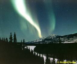
The Aurora Borealis
Relax and enjoy the most relaxing, mesmerizing hour in
FS. Oh yes, occasionally check back to
the cockpit to make sure you don’t over fly Old Crow.
CYOC – CEZ2. Well
lets see what we have here, after climbing to our altitude of 5500’ and on
course we are blinded by the perils if winter Bush flying, the bright sun very
low in the sky, the sun reflecting off the snow and the mountain peaks hidden
in the brightness. Set a course for Ogilvie
River and stay alert. After passing Ogilvie the mountains seem to
be getting higher, you are the PIC you make the decisions. Finding the valley to Chapman
Lake is a chore what with the sun
and everything else.
I bet you where spending your concentration on that lake
and not paying attention to that little insignificant strip off to the left
there, Right? You wouldn’t think I
would pick a strip that was so easy to find as right next to the lake now would
you?
CEZ2 –PAEA - CHP. Lets do this
leg this way, you know after the approach to Chapman
Lake that it will take 7500’ to get
out of here, so lets get on up there. We will head to Eagle for a quick stop
clearing US Customs and Immigrations, then we head to Circle Hot Springs. We should be able to fly this leg at 6500’
and as the terrain changes get on down to 2500’. Nothing really challenging for these two legs.
CHP – PABT. We are
departing Circle Hot Springs at 13:00,
heading home to Bettles. I can smell
that Barbecue from here. Understand
that Capt Brett will have a huge Bon Fire for us to sit around eating our
Barbecue Caribou and a lot of other great food; understand he is a superb
Chef. He indicated to me that we could
expect some hot-buttered rum. But we
have to get there first, so we will be climbing out to 6500’. I have flown this leg many times and during
the winter have never missed having a snowstorm, but looks like we will not
have one this trip, shucks! Looking at
the terrain ahead we can come down to 4500’ and those not faint of heart, you
can get down lower. Pay attention when
those taller mountains start appearing ahead.
I planned the departure time so that we would end this Toughman
Challenge with a final show of the Aurora Borealis and there it is, isn’t it
beautiful and so befitting our exploits.
I sure have enjoyed this flight and hope you did as well,
guess I will hear it all around the Bon Fire. Now that this is over, for those
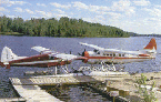
of you that want to linger around at Bettles for a while there are several
Beavers and Otters on floats at out seaport.
Why don’t you check out our flight assignment board and fly that flight
we have listed as “Finding Lake Chandler”.
Coleman has built a cabin and dock there, and I bet if you found the Lake
he would be there with his boat and probably take you fishing. Sure would like to hear from you As for me, I am catching a few airliners as
I fly to Thule to attend a joint
conference on Geological surveys. Bush
Pilots Division is bidding on the air support.
Thanks a million,
Bill Odell
wradodel@tampabay.rr.com