FS 9 TOUGH MAN CHALLENGE # 4 FS 9
By Ron Jorgensen
FLOAT/AMPHIBIAN PLANE
The following 5 flights are for a
Float/Amphib type of aircraft. They are
all at low altitudes with very low ceilings, rain and/or snow. This will be flying by the seat of your
pants. No Auto Pilot or up and
over. All flights should be in daytime
even though you will not see to much if you follow the weather suggestions. There is no add on scenery, strictly
default. A map is enclosed to be used
with flight #1. This adventure was
developed using FS9. IFR up and over is UNAUTHORIZED.
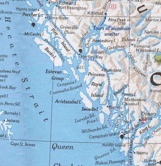
FLIGHT #1
Depart Kitimat (CBW2) southerly to
ZKI VOR (203.0) then down the Kitimat river into the Douglas Channel then
southerly in the
Weather for this flight WILL BE 600' overcast 7 mi
in moderate rain. Use of GPS Map is recommended. (See map for guidance) My time was 61 min.
FLIGHT #2
Depart Carcross (CFA2) south
easterly then south over the river. Turn
left in the
Weather is 3000' overcast 5 miles
in moderate rain/snow. Use of GPS
Map is recommended.
Winds are at your option (put something
in)
FLIGHT #3
CYXC north, following the river,
to CYGE.
Your ASSIGNED altitude is 3500' MAX. Fly north until you reach CAA8 where the
river goes underground and your new altitude is 4,000'. Use of
GPS Map is recommended.
Weather is not good. 5,000' Overcast 5 to 7 miles in moderate to
heavy snow. Winds 310/7
Check points are SX VOR (368.0),
CYCQ, CAA8 & CBL6. My time 55 min
FLIGHT #4
Lets come back to Golden from the
north this time. CAH4 to CYGE. This is a continuation of the same river you
came up. Depart r/w 14 and turn slightly
left to the river. When over the river your ASSIGNED altitude is 3,000'. About 5 miles
south of departure the weather comes down to meet you.
WX 4000' Overcast 5 miles in
moderate to heavy snow. Winds 280/8 Use of
GPS Map recommended.
45 and 35 miles north of Golden
the channel gets very narrow so be careful.
Stay in the center of the channel.
20 Miles north of Golden climb to 4,000' for your approach. My time 68 min